back to articles | August 08, 2024 | Moses Mwangi
Categories: Lifestyle
Motorcycle Routes in California: Journey Through Paradise
California, is a beloved destination by motorcyclists, with journeys that take you around mountains, along the coast, and up close to redwoods.
California, also called the Golden State, is a beloved destination by motorcyclists. They praise it for scenic routes, with journeys that take you around mountains, along the coast, and up close to redwoods. The weather is also something else. Riders enjoy cruising the state all year round, even when bikers in other states break for winter. If you plan to explore California on a two-wheeler this summer, read on to discover its most scenic routes.
Redwood Trail Scenic Byway
The Redwood Trail Scenic Byway takes you through some of the most spectacular views in Northern California. It brings you to the heart of the Redwood Empire, the home to the tallest trees in the world. Did you know Hyperion is the tallest tree in the world, measuring 379.1 feet? Well, this tree and other close contenders reside along this byway.
If you depart from Crescent City, you will immediately be surrounded by the Redwoods' awe-inspiring beauty. Once inside the Redwood National and State Parks system, there are several routes you can take. The Avenue of the Giants, stretching 31 miles along California Highway, is the most popular. It takes you through the Humboldt Redwoods State Park.
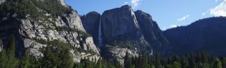
Yosemite National Park
Yosemite National Park lies 170 miles from San Francisco and 280 miles from Los Angeles. It is a natural wonder of North America and is home to El Capitan, North America's largest granite monolith. This vast park covers 759,620 acres and has plenty of scenic routes to explore. The Yosemite Valley Loop is the most famous because it takes you to the park's heart.
Once you are inside the park, head to the Yosemite Village. You can start by entering the visitor's center, where you'll learn about current conditions, wildlife sightings, and road closures. As you leave Yosemite Village and begin the loop, El Capitan will come into view. Along the route, you'll also see the Bridalveil Fall, Half Dome, Yosemite Falls, and Mirror Lake, among other attractions. You can also take the Tioga Road, which traverses the park from west to east.
Pacific Coast Highway
The Pacific Coast Highway (PCH) is one of the most iconic and scenic drives in the United States. It stretches 655 miles from Dana Point in Southern California to Leggett in Northern California. It hugs the coastline, offering breathtaking views of the Pacific Ocean, dramatic cliffs, pristine beaches, and charming coastal towns.
While it's possible to cover the entire route within a day if you travel non-stop, it's recommended that you take at least three days. That way, you can enjoy the thrilling curves and spectacular scenery and visit various attractions along the route. The most stunning part of the highway is Big Sur, where the road winds along rugged cliffs.
Angeles Crest Highway
The Angeles Crest Highway is a must-take route if you are within Los Angeles. It stretches 66 miles through the San Gabriel Mountains, starting in La Caada Flintridge and ending in Wrightwood. As you leave La Caada Flintridge, the road begins to climb rapidly into the mountains, offering spectacular views of the Angeles National Forest, Mojave Desert, and LA basin. A series of challenging and exhilarating switchbacks mark the ascent.
Experienced riders looking for an even more challenging route can detour from the Upper Big Tujunga Canyon Road. Otherwise, proceed to Mount Wilson Observatory for paranoiac views of the LA basin and Angeles National Forest. Don't forget to stop by Newcomb's Ranch for a hearty meal and drinks. This is a popular motorcycle joint along this route.
Death Valley National Park
Death Valley National Park is nicknamed the "land of beautiful yet dangerous extremes." And true to this, there is nothing "normal" about it: this park is home to unique geographical formations. Although the park has many scenic routes, the 17-mile stretch between Badwater Basin and Furnace Creek is the most popular route.
Badwater Basin is the lowest point in North America. You can make various stops along the way, including the Ubehebe crater. Once in Furnace Creek, you can take a scenic but less traveled route to Dante's View. The viewpoint stands at an elevation of 5,475 feet, and you will be rewarded with views of the entire valley.
Lake Tahoe Loop
Lake Tahoe is a beautiful lake nestled in the Sierra Nevada Mountains. It is the largest alpine lake in North America. The Lake Tahoe Loop encircles the lake, allowing you to experience its crystal-clear waters, lush forests, majestic mountains, and charming lakeside communities.
Start at South Lake Tahoe town and proceed west, passing by Emerald Bay State Park. The road here winds along the cliffs, offering stunning views of the bay below. Proceed along the same route, passing through D.L. Bliss State Park, Meek Bay, Kings Beach, Spooner Lake, and Zephyr Cove to return to South Lake Tahoe.
Rock Creek Road to Mammoth Lakes
Rock Creek Road is a short but incredibly scenic ride through the Eastern Sierra Nevada Mountains. It begins in Rock Creek and ends in Mammoth Lakes at an elevation of 7,191 feet. It takes you through some of California's most stunning alpine scenery, including dramatic mountain peaks, lush meadows, and crystal-clear lakes.
Start your ride in the U.S. Highway 395. The highway is known for its stunning vistas and is a gateway to many of the Eastern Sierra's natural wonders. As you approach Rock Creek Road, you'll be treated to views of the towering Sierra peaks and the wide-open expanse of the Owens Valley.
The landscape dramatically changes as you turn onto Rock Creek Road. The road winds through a narrow canyon, with steep granite walls rising on either side. The pavement is smooth and well-maintained but with plenty of twists and turns. As you climb higher, you'll be surrounded by dense pine and aspen forests, and then shortly, you will see Rock Creek Lake.
Sierra Heritage Scenic Byway (Route 168)
Route 168 is another scenic motorcycle route in California. The 60-mile stretch goes through the Sierra Nevada Mountains, offering breathtaking landscapes and many outdoor activities. The route starts at the foothill near Clovis, a charming city with a rich Western heritage.
Before heading further, consider a detour to Millerton Lake State Recreation Area, just north of Fresno. You can enjoy various recreational activities, including boating, fishing, and hiking. From here, continue on Route 168 to Shaver Lake, Huntington Lake, Kaiser Pass, Florence Lake, Edison Lake, and Mono Hot Springs.
Feather River Scenic Byway
The Feather River Scenic Byway spans 130 miles along State Route 70. This byway offers motorcyclists a thrilling journey through diverse landscapes, including rugged canyons, serene riverbanks, lush forests, and historic towns.
The route is renowned for its engineering marvels, scenic vistas, and opportunities for outdoor adventures. Some of the most popular attractions on this route include Lake Almanor, Feather River Canyon, Tobin and Tobin Twin Bridges, Portola, and the Western Pacific Railroad Museum.
Palomar Mountain Road
The Palomar Mountain Loop is a route you can't miss if you are in the San Diego area. The road takes you through Cleveland National Forest to Palomar Mountain. Start from Pauma Valley and head southwest using CA-76, then turn to Palomar Mountain Road S6.
The sight on both sides of the road is stunning, and the twists and turns will keep you engaged. Stop by the Palomar Mountain Viewpoint, then continue on E Grade Road S7 till you reach the Henshaw Scenic Vista Observation Site. At the end of this road, enter the CA-76 to take you back to Pauma Valley.
Mount Hamilton Loop
If you want to escape the bustle of San Jose, the Mount Hamilton Loop is an excellent route for a day trip. Start by taking CA-130 E to Observatory Peak Road. Stop at the Lick Observatory for stunning views of the valley below from an altitude of close to 4,200 feet.
Once done, continue with CA-130 for about 33 miles until you reach Livermore. Make a left on Tesla Road to get to S Livermore Avenue, another left on Concannon, and another left onto Holmes to get to Vallecitos. From here, take the CA-84 and head back to San Jose.
Emigrant Trail Scenic Byway
The Emigrant Trail Scenic Byway is one of Northern California's most historically rich and visually captivating areas. It follows the path of the historic Emigrant Trail used by pioneers during the westward expansion of the United States. You will depart from New Pine Creek and travel south on Highway 395, where the beauty of the Modoc Plateau will greet you. These are vast expanses, volcanic formations, and sagebrush-covered plains.
Transition to Highway 299 to take you deeper into Modoc National Forest and then to Adin. This is a great place to stop, stretch your legs and eat. Afterwards, proceed to Tule Lake. As you approach Tule Lake, the landscape will change again, and you'll begin to see rich agricultural land. You can visit Tule Lake National Wildlife Refuge or the Tule Lake Segregation Center for a history lesson.
Conclusion
California is a haven for motorcyclists looking for scenic routes. From the deep canopy of the Nevada Mountains to the giant redwoods of the Redwood Empire and the unique geographical formations of Death Valley National Park, there are plenty of routes to keep you busy every weekend.
Remember that some of these routes may be challenging for new riders. Exercise caution on the road by maintaining the appropriate speed limit and wearing appropriate riding gear. Furthermore, as you will need auto insurance to drive legally in California, ensure you have liability insurance to cover damage or injuries in the event of an accident.